I noticed this in the Visible satellite imagery a couple of days ago and saved some data. If you look closely at the loop below, you'll see a subtle rotation in the clouds northwest of Sioux Falls, SD:
(click on the image to see a larger version)
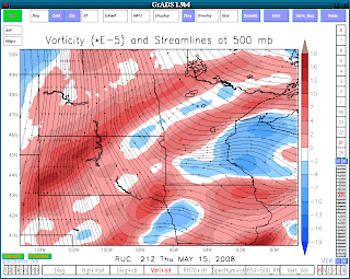
When comparing this with the 20z RUC analysis, you can clearly see the meso-low in the 500mb vorticity fields over the same area:
Kind of cool to see the meso-low being picked up in both the 13km RUC data and in the Visible satellite image.
Labels: computer models, observations, satellite
Clear skies this afternoon are revealing much of the snow-cover across the Northern Plains and upper Midwest... Click on the image below to bring up a loop.
It wasn't a major snowfall, but it was the first snow-storm of the season for some parts of the Midwest. Measurable snow fell for the first time over parts of Nebraska, Kansas, Iowa and southern Wisconsin over the Thanksgiving holiday. Satellite pictures from Saturday clearly showed areas where the heaviest snows fell, particularly over parts of southern and eastern Nebraska, northwestern Kansas, Iowa and southern Wisconsin.
In the satellite loop below, obviously the areas of "white" that arent' moving are where the snow-cover is showing. You can even see snow cover melting over Iowa.